
Path Survey (OTISS)

100+
Downloads

Everyone
info
About this app
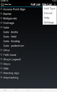
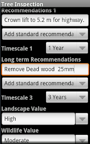
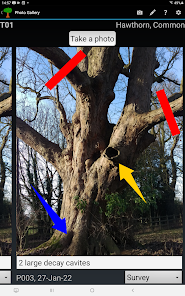
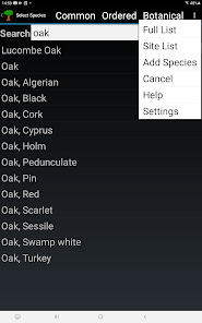
This application is used by staff and volunteers to survey Public Rights of Way and National Trails to monitor the condition of the path, infrastructure (gates, stiles, signs etc.), and also basic tree safety. PathSurvey is part of the OTISS survey system. The app and your GPS-enabled android phone or tablet is an alternative to buying specialised and expensive survey equipment for on-site data collection.
The PathSurvey app. works with the www.otiss.co.uk website to provide a range of maps and tools for carrying out footpath and infrastructure surveys, management and report generation.
All staff and volunteers must first register for an account on the OTISS website. A free 30 day evaluation period is allowed, after which an annual subscription will be charged for continued use of the OTISS system - see the OTISS website for more details. Note: this PathSurvey application is free to download, evaluate and use – no charges are made to your phone or Google accounts.
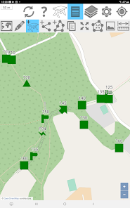
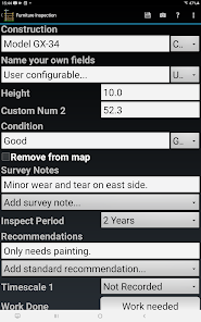
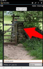
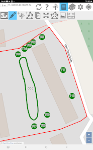
The OTISS system works as follows. (i) First, a survey is created (or authorised) on the OTISS website. (ii) The PathSurvey app is then used to download the survey to the Android device. (iii) The app is used to carry out the survey by placing paths, infrastructure and trees on the map and entering inspection data. (iv) The survey data is then sync’ed back to the OTISS website. (v) OTISS website provides tools to view, modify, analyse and generate reports on the collected inspection data.
The PathSurvey app. works with the www.otiss.co.uk website to provide a range of maps and tools for carrying out footpath and infrastructure surveys, management and report generation.
All staff and volunteers must first register for an account on the OTISS website. A free 30 day evaluation period is allowed, after which an annual subscription will be charged for continued use of the OTISS system - see the OTISS website for more details. Note: this PathSurvey application is free to download, evaluate and use – no charges are made to your phone or Google accounts.
The OTISS system works as follows. (i) First, a survey is created (or authorised) on the OTISS website. (ii) The PathSurvey app is then used to download the survey to the Android device. (iii) The app is used to carry out the survey by placing paths, infrastructure and trees on the map and entering inspection data. (iv) The survey data is then sync’ed back to the OTISS website. (v) OTISS website provides tools to view, modify, analyse and generate reports on the collected inspection data.
Updated on
Safety starts with understanding how developers collect and share your data. Data privacy and security practices may vary based on your use, region, and age. The developer provided this information and may update it over time.

No data shared with third parties
Learn more about how developers declare sharing

This app may collect these data types
Location, Personal info and 2 others

Data is encrypted in transit

You can request that data be deleted
What's new
Release V3.80
+ A major improvement to the way we fill in the reference/tag number for the trees, groups and hedges.
+ While on-site, you can update the Site Description and the Survey Report using the 'Update Survey Info' menu option.
+ When re-surveying a tree, you can use the Record Work Done button to update any recommendations from the 'previous' survey.


