
UTM Geo Map
Contains adsIn-app purchases
4.6star
15.8K reviews
1M+
Downloads

Everyone
info


About this app
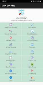
Complete, simple, easy to use & free application for Land Surveying, Topography, Bathymetry & GIS. Suitable for Geodesy Engineering, Civil Engineering, Geology and other disciplines related to maps, coordinates, location, address and spatial analysis. Can be used as a tool in determining position, coordinates, location & address, area & distance measurement, simple spatial analysis such as Overlay, Buffering, TIN / Delaunay Triangulation, Voronoi Diagram, Convex Hull, Smoothing, show WMS Map (Map Server) etc.
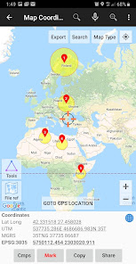
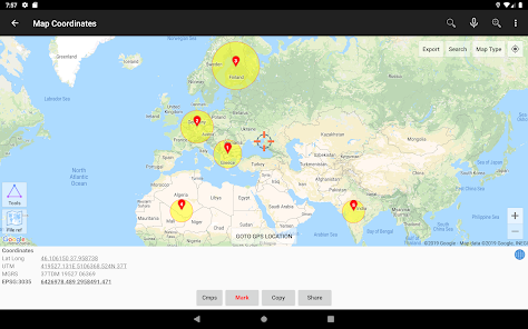
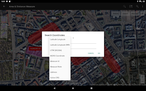
Map Coordinates: Can be used to obtain Latitude Longitude, UTM, MGRS (WGS84) & other CRS (using EPSG codes) in real time, register points complete with coordinate data, time taken, notes/labels, elevation (premium), addresses, photos etc. This module can also display TIN, Voronoi Diagrams and Buffers in realtime from existing points.
Offline GPS: Used to get coordinates in an offline state (without internet access), your cellphone will function like a Handheld GPS to get Latitude Longitude coordinates, UTM, MGRS, Elevation (ellipsoid), MSL Elevation (EGM96), accuracy, satellite and other useful information. Coordinates data can be stored in an unlimited number inside your databases, given notes / labels, photos or exported into CSV, KML, DXF & GPX formats.
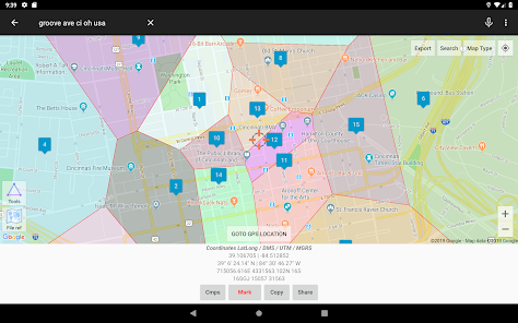
Coord. Converter: To convert coordinates manually from Latitude Longitude to UTM & MGRS and vice versa. It can also be used to convert addresses to coordinates (Geocoding, requires an internet connection). Some conversion is support for batch conversion.
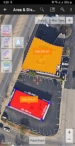
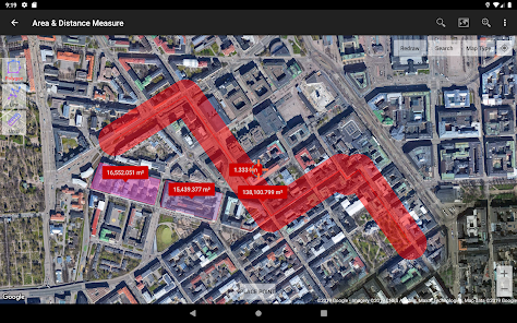
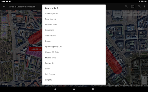
Area/Distance: Used to measure distance and area (support units: m, km, ft, miles, hectare, acre), register lines / polygons, make polygons automatically from measure points, create buffers from lines / polygons, overlay etc.. Line / polygon data can be stored in unlimited number inside your database, displayed on a map, added photos and labels or exported to CSV, KML or DXF format. Equipped with spatial editing algorithms such as Snap Nearest, Delete Object Inside / Outside Polygon, Smoothing (cubic bezier interpolation), Split Polygon By Line, and so on. Can read CSV & KML formats to import or display as reference files.
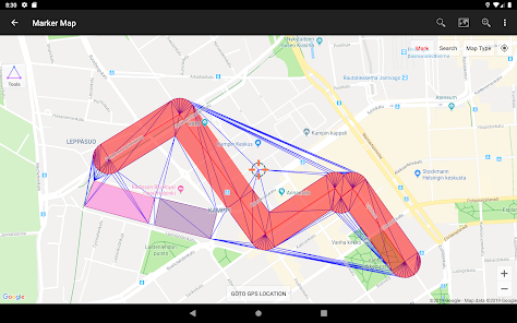
Marker Map: Similar to the Map Coordinates module but with more complete & complex geometry calculation such as displaying Dynamic / Variable Buffers. In this module geometric analysis such as TIN & Voronoi Diagrams can be made from a combination of point data (markers) as well as lines and polygons (breakline). These geometries can also be exported to KML or DXF files for use on other devices or PC.
Compass Map: Module with a map and compass with magnetic declination, can be used to assist in navigating or measuring the azimuth angle and determining distance & direction.
Buffer/Overlay: Module to perform buffering & overlays (and other GIS operations) with several options including Union, Intersection, Difference and Symmetrical Difference.
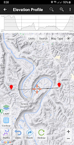
Elevation Profile: Used to create simple elevation profiles (cross section / long section) from height data with metric & ft / mile units. This module can also create elevation profiles from multiple points including elevation profile from route (premium).
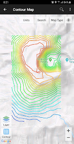
Contours: Module to generate contours based on number of contour lines, desired elevation or contour interval. This is premium module & need internet connection.
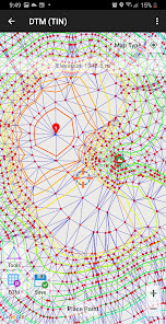
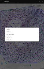
DTM: Digital Terrain Model, module to generate TIN / GRID surface & Contour Lines from elevation data. Calculate Cut And Fill volume, TIN refinement, Grid interpolation and dynamic Elevation Profile.
Some other modules.
Website: https://www.utmgeomap.com
Quick guide (pdf): https://www.utmgeomap.com/utmgeomapquickstart.pdf
YouTube: https://www.youtube.com/channel/UCspxQ5nQiqRD88g_-6GcCqw
Any suggestions are welcome, please submit via email to utmgeomapapp@gmail.com or write a review. Thanks.
Map Coordinates: Can be used to obtain Latitude Longitude, UTM, MGRS (WGS84) & other CRS (using EPSG codes) in real time, register points complete with coordinate data, time taken, notes/labels, elevation (premium), addresses, photos etc. This module can also display TIN, Voronoi Diagrams and Buffers in realtime from existing points.
Offline GPS: Used to get coordinates in an offline state (without internet access), your cellphone will function like a Handheld GPS to get Latitude Longitude coordinates, UTM, MGRS, Elevation (ellipsoid), MSL Elevation (EGM96), accuracy, satellite and other useful information. Coordinates data can be stored in an unlimited number inside your databases, given notes / labels, photos or exported into CSV, KML, DXF & GPX formats.
Coord. Converter: To convert coordinates manually from Latitude Longitude to UTM & MGRS and vice versa. It can also be used to convert addresses to coordinates (Geocoding, requires an internet connection). Some conversion is support for batch conversion.
Area/Distance: Used to measure distance and area (support units: m, km, ft, miles, hectare, acre), register lines / polygons, make polygons automatically from measure points, create buffers from lines / polygons, overlay etc.. Line / polygon data can be stored in unlimited number inside your database, displayed on a map, added photos and labels or exported to CSV, KML or DXF format. Equipped with spatial editing algorithms such as Snap Nearest, Delete Object Inside / Outside Polygon, Smoothing (cubic bezier interpolation), Split Polygon By Line, and so on. Can read CSV & KML formats to import or display as reference files.
Marker Map: Similar to the Map Coordinates module but with more complete & complex geometry calculation such as displaying Dynamic / Variable Buffers. In this module geometric analysis such as TIN & Voronoi Diagrams can be made from a combination of point data (markers) as well as lines and polygons (breakline). These geometries can also be exported to KML or DXF files for use on other devices or PC.
Compass Map: Module with a map and compass with magnetic declination, can be used to assist in navigating or measuring the azimuth angle and determining distance & direction.
Buffer/Overlay: Module to perform buffering & overlays (and other GIS operations) with several options including Union, Intersection, Difference and Symmetrical Difference.
Elevation Profile: Used to create simple elevation profiles (cross section / long section) from height data with metric & ft / mile units. This module can also create elevation profiles from multiple points including elevation profile from route (premium).
Contours: Module to generate contours based on number of contour lines, desired elevation or contour interval. This is premium module & need internet connection.
DTM: Digital Terrain Model, module to generate TIN / GRID surface & Contour Lines from elevation data. Calculate Cut And Fill volume, TIN refinement, Grid interpolation and dynamic Elevation Profile.
Some other modules.
Website: https://www.utmgeomap.com
Quick guide (pdf): https://www.utmgeomap.com/utmgeomapquickstart.pdf
YouTube: https://www.youtube.com/channel/UCspxQ5nQiqRD88g_-6GcCqw
Any suggestions are welcome, please submit via email to utmgeomapapp@gmail.com or write a review. Thanks.
Updated on
Safety starts with understanding how developers collect and share your data. Data privacy and security practices may vary based on your use, region, and age. The developer provided this information and may update it over time.

This app may share these data types with third parties
Location, App activity and 2 others

No data collected
Learn more about how developers declare collection

Data is encrypted in transit

Data can’t be deleted
Ratings and reviews
4.6
15.5K reviews

W T Whitacre
- Flag inappropriate
September 25, 2022
Great app. Many features. Really like the export function! I'm an engineer and use the app out in the field on an irregular basis to verify field conditions at project sites. The problem with the app is many features require unlocking with a 3 mo subscription with no yearly or permanent option. I use the app at field sites that a lot of times Don't Have Cell Service ! No Way to Buy or update a subscription at those sites if you need to use one that has expired ! Can't add Needed things then.
49 people found this review helpful

A Google user
- Flag inappropriate
- Show review history
April 24, 2020
The app has a lot of awesome features and is easier to use than other gps apps I have worked with. However, the second day I used it (after deciding to purchase the premium version) the app crashed over and over and 12 marker points I had saved were deleted. My coworker downloaded the app on his smartphone so that we could finish our field work for the day and within 10 minutes his app was crashing. We ended up using a different app. Pretty disappointed.
58 people found this review helpful
Y2 Tech
April 27, 2020
We are very sorry, there is an issue on the google map server that causes many applications to crash, we are one of them. The solution that can be done for now is to clear app data or uninstall & reinstall the app. You can see the progress here: https://issuetracker.google.com/issues/154855417
*Edit: please update our APP to the latest version

eric Thompson
- Flag inappropriate
March 27, 2021
Liking this so far. Effectively imported my .kml list of points AND actually let me view them at the same time on the map. (Why this is hard to find in other apps, I dunno.) The variable buffer is quite nice. MY QUESTION: it would be very nice to be able to format that buffer; e.g. change color or have no fill color. Is that possible? A future option?
38 people found this review helpful
Y2 Tech
March 27, 2021
Thank you very much. Technically possible, we will consider that.
What's new
This version comes with lots of backend improvements. Happy mapping!.


