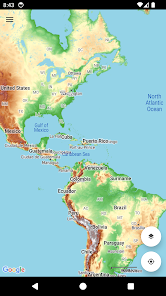
World Topo Map
Contains adsIn-app purchases
4.1star
506 reviews
100K+
Downloads

Everyone
info

About this app
Topographic map of the world with no limitations:
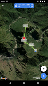
• View and cache topographic tiles and satellite imagery
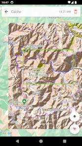
• Download all topographic tiles in a visible region (for offline availability)
• Add unlimited map markers
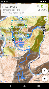
• Import GPX / KML / FIT waypoints, tracks and routes
• Record routes (export and share)
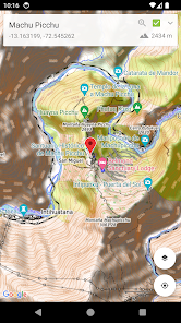
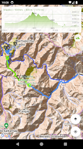
• View track / route elevation profile (with interactive graph)
• Measure distance (in a straight line) between multiple points and markers
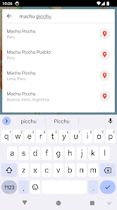
• Search for places of interest (supports decimal coordinates)
• Group markers by tag for easy organisation (change colours, toggle visibility)
• Battery conscious (for those that can't recharge every day)
• Space conscious (for those that don't have gigabytes to spare; external SD card support; full tile cache control)
• Stay up-to-date with the latest imagery (no dependency on application updates)
• Navigate with Google Maps interactions (pinch zoom, scroll, rotate, drop marker, drag marker etc)
• Fully functional for free!
World Topo Map is intended for outdoor enthusiasts who want to mark locations visited, create markers to visit, follow imported tracks or create their own. It's designed to be lightweight, intuitive, responsive, battery conscious and totally free. Perfect for casual day trips to serious bush excursions.
Developed by an adventurous person for adventurous people!
Topographic Map Tiles
OpenTopoMap is a free, topographic map generated from the data in the OpenStreetMap and SRTM elevation data.
This service provides excellent topographic coverage of most of the globe, however there may be areas and zoom levels with no topographic information.
OpenTopoMaps is licensed under
Kartendaten: © OpenStreetMap-Mitwirkende, SRTM | Kartendarstellung: © OpenTopoMap (CC-BY-SA)
Analytics
World Topo Map uses Google Analytics to anonymously send application metrics to measure stability of the app. No personal information is sent, used or disclosed.
For further information about Google Analytics, see http://www.google.com/analytics. For details of the Google Analytics Privacy Policy see http://www.google.com/policies/privacy
You can opt out of Google Analytics anytime under the Settings menu.
• View and cache topographic tiles and satellite imagery
• Download all topographic tiles in a visible region (for offline availability)
• Add unlimited map markers
• Import GPX / KML / FIT waypoints, tracks and routes
• Record routes (export and share)
• View track / route elevation profile (with interactive graph)
• Measure distance (in a straight line) between multiple points and markers
• Search for places of interest (supports decimal coordinates)
• Group markers by tag for easy organisation (change colours, toggle visibility)
• Battery conscious (for those that can't recharge every day)
• Space conscious (for those that don't have gigabytes to spare; external SD card support; full tile cache control)
• Stay up-to-date with the latest imagery (no dependency on application updates)
• Navigate with Google Maps interactions (pinch zoom, scroll, rotate, drop marker, drag marker etc)
• Fully functional for free!
World Topo Map is intended for outdoor enthusiasts who want to mark locations visited, create markers to visit, follow imported tracks or create their own. It's designed to be lightweight, intuitive, responsive, battery conscious and totally free. Perfect for casual day trips to serious bush excursions.
Developed by an adventurous person for adventurous people!
Topographic Map Tiles
OpenTopoMap is a free, topographic map generated from the data in the OpenStreetMap and SRTM elevation data.
This service provides excellent topographic coverage of most of the globe, however there may be areas and zoom levels with no topographic information.
OpenTopoMaps is licensed under
Kartendaten: © OpenStreetMap-Mitwirkende, SRTM | Kartendarstellung: © OpenTopoMap (CC-BY-SA)
Analytics
World Topo Map uses Google Analytics to anonymously send application metrics to measure stability of the app. No personal information is sent, used or disclosed.
For further information about Google Analytics, see http://www.google.com/analytics. For details of the Google Analytics Privacy Policy see http://www.google.com/policies/privacy
You can opt out of Google Analytics anytime under the Settings menu.
Updated on
Safety starts with understanding how developers collect and share your data. Data privacy and security practices may vary based on your use, region, and age. The developer provided this information and may update it over time.

This app may share these data types with third parties
Location, App activity and 2 others

No data collected
Learn more about how developers declare collection

Data is encrypted in transit

Data can’t be deleted
Ratings and reviews
4.2
472 reviews

Greatheavy
- Flag inappropriate
- Show review history
August 14, 2022
Great app, I've used it for the last 4 years (after getting lost during a hike :) ), perfect to load a track, follow it, very accurate and details map, good GPS integration => It became my reference app for any hike. Just wish we could plot ahead - I'm currently using another app and then import the track. But what can I say. It works very well as is. Thanks!
2 people found this review helpful
Mason Blackwood
August 17, 2022
Hi Alex, thanks for taking the time to rate and review, it's appreciated! Great to hear you're enjoying the app and no longer getting lost :) I'm always keen to hear how the app can be improved, so suggestions welcome. If you like, please email me at worldtopomap@gmail.com so we can discuss further. Kind regards, Mason

John Till
- Flag inappropriate
July 6, 2020
Great to have an easy way to access open source topographic maps with trails. Your phone GPS works without a cell signal since it only needs to triangulate using satellite signals. Pair that with the "snapshot" feature to download maps for offline use, and you have an excellent navigation method. GPS can fail to get a signal sometimes, so it still pays to have some navigation skills.
9 people found this review helpful

Guillaume Dupont
- Flag inappropriate
- Show review history
February 24, 2024
A very very useful application for trail running and hiking in unfamiliar terrain. Ideal to review a GPX track while preparing a hike/run beforehand and to know where you are and where you need to go once on a hike. It is fast. Does not use much battery, you can download free topo maps offline. The developer is opened to suggestions to improve it.
5 people found this review helpful
What's new
• Bug fixes and UI improvements
More feature requests coming soon!
More feature requests coming soon!


