

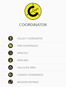
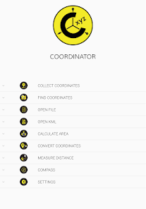
Coordinator-Collect Coordinate
Contains adsIn-app purchases

4.3star
2.72K reviews
100K+
Downloads

Everyone
info


About this app
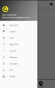
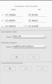
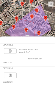
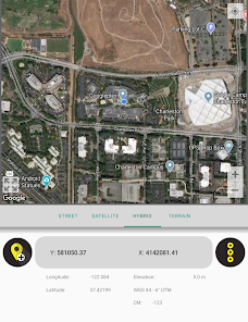
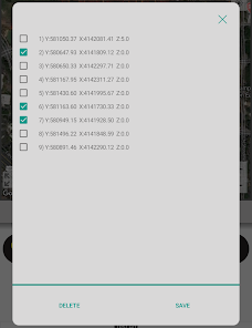
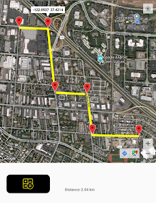
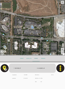
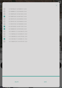
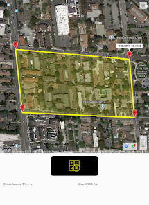
Using Coordinator app, you can collect coordinate data from land on whatever coordinate system you want, choosing from defined systems. You can collect GPS coordinates. You can use the app as a GPS tracker. You can view a coordinate data on the map and also search by address and see that on the map. You can get directions to that point. You can search by longitude/latitude. You can convert an existing coordinate into another coordinate system. You can do this by typing coordinates manually or opening an XLSX file which contains coordinates. You can display circumference and area measurements of some coordinates by opening the file which created before. Also you can measure distance and area for some coordinates which determined manually on the map. You can display a KML file on the map. There is also a compass tool. Coordinator app contains several useful tools for people interested in coordinates, maps and geographic information systems (GIS).
All of the features above are free.
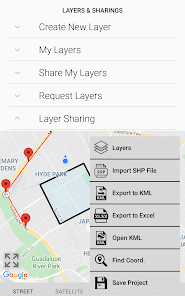
On the other hand if you become a Coordinator Pro subscriber, you can benefit from many extra features in addition to these features. With Coordinator Pro, subscribers can use some extra features such as Cloud Database Functions (creating points, lines & polygons, sharing your layers with teammates, working simultaneously with teammates, working offline and synchronizing, etc), exporting to KML & Excel files, making elevation & address querying and so on. It is ad-free.
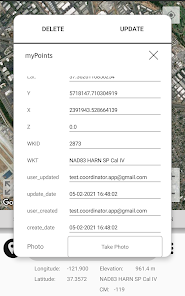
Besides longitude/latitude, subscribers can find out the altitude value of a point on the map. You can search by address and so that locate it on the map and learn the GPS coordinate (longitude/latitude or northing/easting) value of this place. The address locating feature works based on maps services and it's very effective.
If you are a subscriber, you can use the Coordinator Web app. So that you can use the cloud database features of the Coordinator app on the web page on your computer and monitor the data instantly. You can view/track and edit cloud database data on the web page. In this way, you can instantly monitor the data movements made in the mobile app in the field, in the web browser on your computer.
The coordinate systems of the countries, which the app is most downloaded, are added to the app.
Current list of the countries and their coordinate systems defined in this app:
World - GPS(WGS 84)
World - WGS 84 - 6 ̊ UTM
United States - "NAD 1983 HARN State Plane Coordinate Systems(meters & feet)" and "Military Grid Reference System (MGRS)"
Algeria - "Nord Sahara 1959 / UTM 6 ̊ "
Azerbaijan - "Pulkovo 1942 / Gauss-Kruger 3 ̊ " and "Pulkovo 1942 / CS63"
Bulgaria - "Pulkovo 1942(58) GK 6 ̊ "
Germany - "DHDN/3 ̊ GK" and "ETRS89 UTM 6 ̊"
India - "Kalianpur 1975 / India" and "Kalianpur 1975 / UTM 6 ̊"
Indonesia - "Indonesia 1974 UTM 6 ̊" and "DGN 1995 Indonesia TM3 ̊"
Iran - "ED50(ED77) / UTM 6 ̊"
Iraq - "Nahrwan 1967 / UTM 6 ̊" and "ED50 / Iraq National Grid" and "Karbala 1979 / UTM 6 ̊"
Israel - "Palestine 1923/Palest. Grid" and "Palestine 1923/Israeli CS Grid" and "Israel 1993/Israeli TM Grid"
Lebanon - "Deir ez Zor / Levant Ster." and "Deir ez Zor / Syria Lambert"
Mauritania - "Mauritania 1999 / UTM 6 ̊"
Morocco - "Merchich / Nord Maroc" and "Merchich / Sud Maroc"
Netherlands - "Amersfoort / RD New" and "Amersfoort / RD Old"
Palestine - "Palestine 1923/Palest. Grid" and "Palestine 1923/Israeli CS Grid" and "Israel 1993/Israeli TM Grid"
Philippines - "Luzon 1911 / Philippines" and "PRS92 / Philippines"
Romania - "Dealul Piscului 1930 / Stereo 33" and "Pulkovo 1942(58) / Stereo 70"
Russia - "Pulkovo 1942 / Gauss-Kruger 3 ̊"
Saudi Arabia - "Ain el Abd / UTM 6 ̊" and "Ain el Abd / Aramco Lambert"
Syria - "Deir ez Zor / Levant Ster." and "Deir ez Zor / Syria Lambert"
Turkey - "ITRF 96 - 3 ̊" and "ED 50 - 3 ̊" and "ITRF 96 - 6 ̊" and "ED 50 - 6 ̊"
United Arab Emirates - "Nahrwan 1967 / UTM"
All of the features above are free.
On the other hand if you become a Coordinator Pro subscriber, you can benefit from many extra features in addition to these features. With Coordinator Pro, subscribers can use some extra features such as Cloud Database Functions (creating points, lines & polygons, sharing your layers with teammates, working simultaneously with teammates, working offline and synchronizing, etc), exporting to KML & Excel files, making elevation & address querying and so on. It is ad-free.
Besides longitude/latitude, subscribers can find out the altitude value of a point on the map. You can search by address and so that locate it on the map and learn the GPS coordinate (longitude/latitude or northing/easting) value of this place. The address locating feature works based on maps services and it's very effective.
If you are a subscriber, you can use the Coordinator Web app. So that you can use the cloud database features of the Coordinator app on the web page on your computer and monitor the data instantly. You can view/track and edit cloud database data on the web page. In this way, you can instantly monitor the data movements made in the mobile app in the field, in the web browser on your computer.
The coordinate systems of the countries, which the app is most downloaded, are added to the app.
Current list of the countries and their coordinate systems defined in this app:
World - GPS(WGS 84)
World - WGS 84 - 6 ̊ UTM
United States - "NAD 1983 HARN State Plane Coordinate Systems(meters & feet)" and "Military Grid Reference System (MGRS)"
Algeria - "Nord Sahara 1959 / UTM 6 ̊ "
Azerbaijan - "Pulkovo 1942 / Gauss-Kruger 3 ̊ " and "Pulkovo 1942 / CS63"
Bulgaria - "Pulkovo 1942(58) GK 6 ̊ "
Germany - "DHDN/3 ̊ GK" and "ETRS89 UTM 6 ̊"
India - "Kalianpur 1975 / India" and "Kalianpur 1975 / UTM 6 ̊"
Indonesia - "Indonesia 1974 UTM 6 ̊" and "DGN 1995 Indonesia TM3 ̊"
Iran - "ED50(ED77) / UTM 6 ̊"
Iraq - "Nahrwan 1967 / UTM 6 ̊" and "ED50 / Iraq National Grid" and "Karbala 1979 / UTM 6 ̊"
Israel - "Palestine 1923/Palest. Grid" and "Palestine 1923/Israeli CS Grid" and "Israel 1993/Israeli TM Grid"
Lebanon - "Deir ez Zor / Levant Ster." and "Deir ez Zor / Syria Lambert"
Mauritania - "Mauritania 1999 / UTM 6 ̊"
Morocco - "Merchich / Nord Maroc" and "Merchich / Sud Maroc"
Netherlands - "Amersfoort / RD New" and "Amersfoort / RD Old"
Palestine - "Palestine 1923/Palest. Grid" and "Palestine 1923/Israeli CS Grid" and "Israel 1993/Israeli TM Grid"
Philippines - "Luzon 1911 / Philippines" and "PRS92 / Philippines"
Romania - "Dealul Piscului 1930 / Stereo 33" and "Pulkovo 1942(58) / Stereo 70"
Russia - "Pulkovo 1942 / Gauss-Kruger 3 ̊"
Saudi Arabia - "Ain el Abd / UTM 6 ̊" and "Ain el Abd / Aramco Lambert"
Syria - "Deir ez Zor / Levant Ster." and "Deir ez Zor / Syria Lambert"
Turkey - "ITRF 96 - 3 ̊" and "ED 50 - 3 ̊" and "ITRF 96 - 6 ̊" and "ED 50 - 6 ̊"
United Arab Emirates - "Nahrwan 1967 / UTM"
Updated on
Safety starts with understanding how developers collect and share your data. Data privacy and security practices may vary based on your use, region, and age. The developer provided this information and may update it over time.

No data shared with third parties
Learn more about how developers declare sharing

This app may collect these data types
Location, Personal info and 3 others

Data is encrypted in transit

You can request that data be deleted
Ratings and reviews
4.3
2.68K reviews

A Google user
- Flag inappropriate
- Show review history
October 27, 2019
it gives x and y coordinates and altitude(z coordinate) according to different systems and countries. For example if you have been living in Turkey, you need to choose collect coordinates then Turkey option then the system option you need (ed50 6 utm was wanted from me because i am a mine engineer), and then you can see decimal degrees and x, y coordinates easily. z is altitude from the sea level and although z symbol isn't written, you can see it as altitude.
36 people found this review helpful
DER Soft
October 29, 2019
Thanks for your explanations and the 5 star rating. Hope you continue to enjoy using our app. If you have any feedback or suggestions, please write to us at info@coordinatorapp.net. We would love to hear from you!
A Google user
- Flag inappropriate
- Show review history
September 19, 2018
I was excited to see that US State Plane coordinates are supported, but there does not seem to be a setting to display the results in US feet, the native system for US State Plane coordinates. Having to manually convert meters to feet makes this feature too cumbersome.
19 people found this review helpful
DER Soft
October 4, 2018
We will be working to add the US State Plane Coordinate System in US feet. In next updates, we will be adding it. Thanks for your interest..

kometa0017
- Flag inappropriate
- Show review history
September 5, 2022
The app is asking for credit card details before it actually had been tried. Sorry developers but I don't trust that it can do the job for me accurately enough. Can't comment on the functionality as I can't try the app, as I can't progress beyond the credit card details screen.
8 people found this review helpful
DER Soft
September 6, 2022
Hello. We think you misunderstood. You can use the app without subscribing. If you subscribe, you can use it ad-free with extra features. So you can use it without entering credit card info. You don’t have to enter credit card account info. Just tap on the tool name on the left. For example tap “Collect” and use it. That is all.
What's new
Some bug fixes and performance improvements.