
topoguide Greece
In-app purchases
10K+
Downloads

Everyone
info

About this app
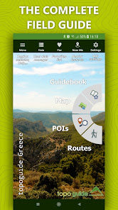
Topoguide gives access to all topoguide.gr hiking destinations with even more content than the website!
The free version gives access to a demo destination: Lycabettus in Attica region.
The other destinations are sold as in-app products, each with:
• Thousands of hiking and cyclings routes with descriptions and photos
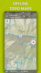
• Offline topographic maps of the area
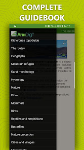
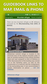
• Guidebook with an extensive introduction on the geography, the nature and the paths of the area
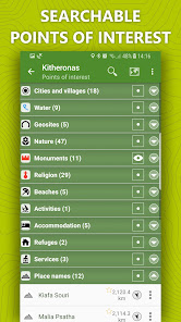
• Offline search for hundreds of POIs
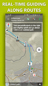
In the field, the app identifies the nearest route, guides you to it and then along it by displaying messages and warnings on every junction or other important location. On each Point of Interest, photos and texts are displayed on the map. If the hiker gets off-trail, the app indicates the shorter way to get back safely.
Topoguide's team of cartographers has previously published hundreds of detailed hiking maps for Greece. To ensure data accuracy, all routes provided in our app are walked or driven by our team.
The available destinations are:
• Long Trails: Menalon Trail, Corfu Trail, National Trail Ο22, Ursa Trail, Long Pelion Trail, Nestos-Rodopi Trail
• Attica: Athens birding, Geraneia, Hymettus, Kitheronas, Lycabettus, Parnitha, Pendeli
• Central Greece (including Thessaly): Dirfys, Elikonas, Giona, Nafpaktia Uplands, Oeta, Parnassos, Kirfis, Vardousia, Pelion (Central, Eastern, Southern & Western)
• Peloponnese: Chelmos, Elafonisos, Epidavros, Methana, Poros & Trizinia, Mani (Areopoli, Avia, Kardamili, Tenaro), Menalon Trail, Parnonas, Taygetos, Ziria
• Northern Greece (Epirus, Macedonia & Thrace): Valia Calda, Ursa Trail, Zagori
• Crete: Chania, Elafonisi, Gramvousa, Lefka Ori - Samaria
• Aegean islands (Cyclades, Saronic, Sporades & Dodecanese): Amorgos, Kea, Kythnos, Naxos, Santorini, Serifos, Sifnos, Tinos, Skyros, Kalymnos, Aegina, Hydra
• Ionian islands: Corfu Trail, Kefalonia, Zakynthos
The free version gives access to a demo destination: Lycabettus in Attica region.
The other destinations are sold as in-app products, each with:
• Thousands of hiking and cyclings routes with descriptions and photos
• Offline topographic maps of the area
• Guidebook with an extensive introduction on the geography, the nature and the paths of the area
• Offline search for hundreds of POIs
In the field, the app identifies the nearest route, guides you to it and then along it by displaying messages and warnings on every junction or other important location. On each Point of Interest, photos and texts are displayed on the map. If the hiker gets off-trail, the app indicates the shorter way to get back safely.
Topoguide's team of cartographers has previously published hundreds of detailed hiking maps for Greece. To ensure data accuracy, all routes provided in our app are walked or driven by our team.
The available destinations are:
• Long Trails: Menalon Trail, Corfu Trail, National Trail Ο22, Ursa Trail, Long Pelion Trail, Nestos-Rodopi Trail
• Attica: Athens birding, Geraneia, Hymettus, Kitheronas, Lycabettus, Parnitha, Pendeli
• Central Greece (including Thessaly): Dirfys, Elikonas, Giona, Nafpaktia Uplands, Oeta, Parnassos, Kirfis, Vardousia, Pelion (Central, Eastern, Southern & Western)
• Peloponnese: Chelmos, Elafonisos, Epidavros, Methana, Poros & Trizinia, Mani (Areopoli, Avia, Kardamili, Tenaro), Menalon Trail, Parnonas, Taygetos, Ziria
• Northern Greece (Epirus, Macedonia & Thrace): Valia Calda, Ursa Trail, Zagori
• Crete: Chania, Elafonisi, Gramvousa, Lefka Ori - Samaria
• Aegean islands (Cyclades, Saronic, Sporades & Dodecanese): Amorgos, Kea, Kythnos, Naxos, Santorini, Serifos, Sifnos, Tinos, Skyros, Kalymnos, Aegina, Hydra
• Ionian islands: Corfu Trail, Kefalonia, Zakynthos
Updated on
Safety starts with understanding how developers collect and share your data. Data privacy and security practices may vary based on your use, region, and age. The developer provided this information and may update it over time.

No data shared with third parties
Learn more about how developers declare sharing

No data collected
Learn more about how developers declare collection

Data is encrypted in transit

Data can’t be deleted
What's new
1. "Freeing" the map! Now the best map of Greece is free for streaming and simultaneous caching
2. Many minor functional changes in map and data management
3. Navigate to the start of a route using Google Maps or other navigation applications
4. Advanced navigation mechanism with 4 profiles, tracking with written navigation instructions and with storage and management of navigations
2. Many minor functional changes in map and data management
3. Navigate to the start of a route using Google Maps or other navigation applications
4. Advanced navigation mechanism with 4 profiles, tracking with written navigation instructions and with storage and management of navigations
App support
phone
Phone number
+302103604451
About the developer
Adamakopoulos Triantafyllos
contact@topoguide.gr
Souliou 59
Agia Paraskevi 15343
Greece
undefined

